Our Services (3D Laser Scanning, Measured Surveys & More) ...

Services

Topographical surveys

We use Revit to create detailed topographic maps of an area. Maps imply high accuracy. Topographic map includes all vertical markings and shows the location of trees, bushes, fences, walls, roads…

360 Virtual Tour

360 Virtual tour/ Virtual Tours / Mateport Virtual Tours / Virtual Walk Tours

Point Cloud To 2D Drawings

We provide 3D Point Clouds that can be loaded in various programs and used for creating detailed 3D BIM Revit models, precise as-built AutoCAD drawings…

Point Cloud To 2D Drawings

Point Cloud Surveys

How does a point cloud survey work. Point cloud survey into Revit. Point cloud surveys software & equipment.

Commercial building survey

This type of building includes offices, shops, hairdressing salons, warehouses, etc. The floor plan of commercial building is usually “open”.

3D Laser Scanning

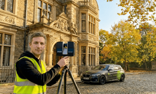
Our Faro 3D laser scanner is capable of capturing up to 1 million points per second. In just minutes the scanner is capable to complete a 360° by 300° scan

3d Laser Scanning
We are in social networks
© All Rights Reserved. Measured Survey Pro.
2018-2025 | LEGAL
CONTACT
If you have any questions or want to discuss your project please do not hesitate to contact us:
Measured Surveys Measured Surveys 347 Barking Road, London, E13 8EE
+44 (0) 203 538 8176
+44 (0) 739 901 1771
WhatsApp
hello@measuredsurveypro.co.uk
© All Rights Reserved. Measured Survey Pro.
2018-2023 | LEGAL