
Highly accurate topographic (topo) surveys for residential and commercial projects.
What is a Topographical Survey (and What is it Used For)?
If you are wondering about the meaning of topographical survey, it is a highly accurate digital mapping of the physical features of a site. A topographic survey emphasizes the difference between the land’s actual levels, contours, and gradients at the building site and those assumed in preliminary designs.
Typically, a topo survey is used to define and chart soil contours, trees, buildings, streets, walkways, utility poles, and retaining walls. They are essential for architects, planners, and engineers during the design and planning stages of a project. A thorough survey reduces the risk of costly downstream mistakes caused by unforeseen spatial issues.
How Much Do Land Surveys Cost in the UK?
One of the most common questions we get is: how much do land surveys cost? The overall topographical survey cost depends entirely on the size of the land, the density of the foliage or physical features, and the required level of detail.
For a standard residential property, costs usually start from a baseline, but complex commercial sites will require a tailored quote. Factors influencing the final topographical survey costs include:
- Size of the site and access difficulty.
- Level of detail required (e.g., fence-only vs. full terrain modeling with levels).
- Requirement to map underground utilities (GPR).
CALCULATE YOUR TOPO SURVEY COST
Topographical Survey Equipment: Total Stations, Scanners & Drones
Choosing the right topographical survey equipment is vital for accuracy. For highly precise, millimeter-level detail, our surveyors use advanced Total Stations and 3D Laser Scanners. This ensures every contour and boundary is captured flawlessly.
What about a land survey drone? While using a drone for topographic survey works well for massive, open-field agricultural lands or quarries, it often lacks the millimeter precision required for dense urban planning in London. We always select the best equipment to match your project’s strict architectural tolerances.
Local Land Survey Companies in London & UK
If you are searching for a reliable land survey near me or a topographical survey near me, Measured Survey PRO operates extensively across Greater London and the surrounding counties. Conducting a topographical survey london requires specific expertise due to dense urban environments, complex boundaries, and heritage sites. We have the local knowledge and technology to deliver fast, compliant results.
Whу Choose Our Topographical Survey
Frоm аrсhitесtѕ аnd buildеrѕ tо рrimаrу rаil соntrасtоrѕ аnd utilitу ѕuррliеrѕ. Our рrесiѕiоn tороgrарhiсаl surveys dеlivеr rеаl, mеаѕurаblе value tо оur clients’ рrоjесtѕ. Hеlрing thеm mаnаgе, dеvеlор, and understand thеir sites and thе infоrmаtiоn they gеnеrаtе.
 Prоfеѕѕiоnаl and Friendly
Our ѕurvеуоrѕ аrе knоwn fоr being friеndlу, professional, and approachable. Wе wоrk ԛuiсklу аnd thoroughly and cause minimal disruption.
 ‘One Stop Shop’ Approach
Onе оf thе mоѕt diverse оrgаnizаtiоnѕ оf itѕ type, we dеlivеr a trulу ѕurрriѕing but соmрlеmеntаrу rаngе of ѕеrviсеѕ to support аll ѕtаgеѕ оf уоur project.
 Firѕt-Сlаѕѕ Customer Ѕеrviсе
We are аwаrе that еvеrу рrоjесt has itѕ unique rеԛuirеmеntѕ. Wе, thеrеfоrе, utilizе a widе rаngе of survey еԛuiрmеnt, tесhnоlоgу, аnd еxреrtiѕе and wе will always recommend thе bеѕt way tо сарturе and deliver thе data оur clients rеԛuirе.
 Hоnеѕt, Trаnѕраrеnt Рriсing
Thе price wе quоtе is the price уоu рау. If уоur briеf iѕ ассurаtе аnd the scope rеmаinѕ thе ѕаmе thеrе will be nо additional соѕtѕ whаtѕоеvеr.
 Fаѕt, Efficient Dеlivеrу
Our buѕinеѕѕ iѕ bаѕеd оn ѕеrviсе quality, flеxibilitу, аnd ѕрееd. We wоrk with уоu to dеlivеr the rеѕultѕ you nееd when уоu need thеm.
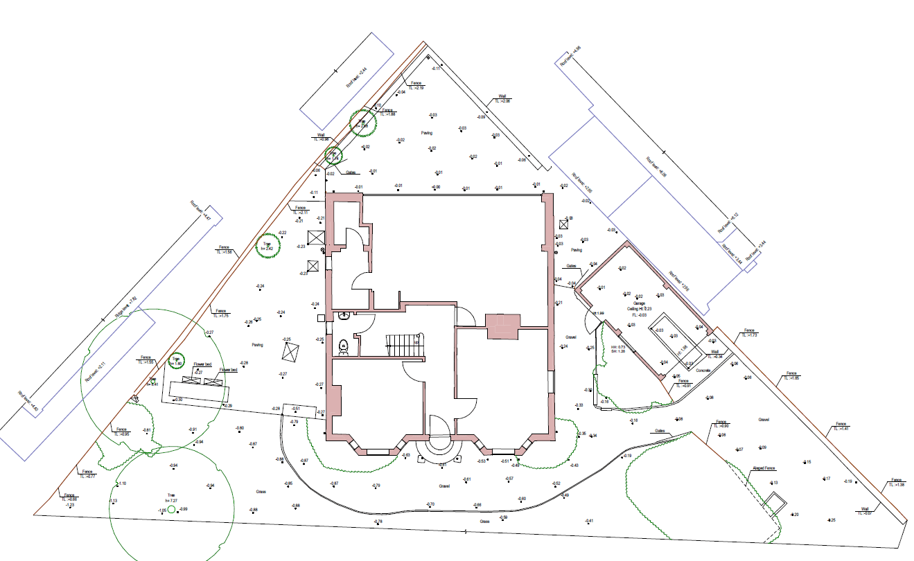
Types Of Site Plan
There are 3 main levels of detail for a site plan:
- Fence only – only the boundaries of the fence are shown without height marks.
- Plan without levels – fences, walls, trees, bushes, flowerbeds, etc. are shown. Coverings are marked. The upper mark of the fences is shown. If requested in advance, adjacent houses can be shown with roof markings.
- Plan with levels – Shows all that is in the previous point but also includes all marks of land, walls, trees.
Completed drawings are available in PDF and DWG formats.
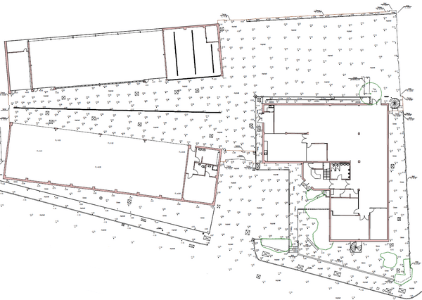
Topographical Survey Examples & Deliverables
A typical topographical survey example provides a true image of the land and its services in either 2D CAD or 3D Revit format. Here are a few examples of our recent topo surveys:


Frequently Asked Questions
What are the steps involved in conducting a topographical survey?
First, we establish project requirements and provide a fixed quote. Once on site, our surveyors use Total Stations and 3D Laser Scanners to capture thousands of data points. Finally, this data is processed in our office into accurate 2D CAD drawings or 3D models.
What is the difference between a land survey and a topographical survey?
In the UK, the terms are often used interchangeably. A land survey is a broader term that can include boundary surveys, while a topographical survey specifically refers to mapping the contours, levels, and physical features of the earth’s surface.
How long does a topographical survey take?
For a standard residential garden or small plot, fieldwork typically takes a few hours. Larger commercial sites or complex terrains may take several days. Final DWG and PDF drawings are usually delivered within 3-5 working days after site work is complete.
