
Professional 3D Laser Scanning for Buildings, Construction & Design
Our laser scanning services capture accurate existing conditions across London and the UK using professional FARO terrestrial laser scanners. We survey the site, register the scan data and deliver the measured information your project actually needs — from a registered Point Cloud to 2D CAD drawings or Revit/BIM models.
London & UK • FARO Laser Scanning • Point Cloud • DWG / PDF • Revit / BIM
Send the site address, existing plans if available and required outputs for a project-specific quotation.
Surveys Completed
1,053+
Drawings Issued
5,877+
Laser Scans Captured
100K+
Our Laser Scanning Service at a Glance
- Interior and exterior 3D laser scanning
- Residential, commercial and industrial buildings
- Measured building and refurbishment projects
- Construction and as-built surveys
- Heritage and complex architectural geometry
- Registered Point Cloud data
- Floor plans, elevations and sections in DWG / PDF
- Revit and BIM modelling options
- London and UK-wide project coverage
Laser Scanning Services for Accurate Existing-Condition Surveys
Professional laser scanning creates a detailed three-dimensional record of a building, structure or site by capturing large quantities of measured spatial data from multiple scanner positions.
For architects, engineers, contractors and developers, the main benefit is simple: design and construction decisions can be based on measured existing geometry rather than assumptions, outdated drawings or a small collection of manually recorded dimensions.
Our surveyors use professional terrestrial laser scanning equipment to capture accessible visible surfaces. The individual scans are then registered together into a coordinated 3D Point Cloud. That dataset can be supplied directly or converted into the drawings or models required by your project.
Laser scanning is the capture service. The resulting Point Cloud is the measured dataset. From that same scan we can also produce CAD floor plans, elevations, sections and Revit/BIM models — so your project team does not need separate survey suppliers for every stage.
What Can We Deliver from a Laser Scanning Survey?
The survey should be planned around the output your project team actually needs. We can provide the registered scan data itself or continue through to finished architectural and BIM deliverables.
Registered Point Cloud
A coordinated three-dimensional record of the accessible visible surfaces captured during the laser scanning survey.
Floor Plans
Measured existing floor plans produced from the registered scan data and supplied in DWG and PDF where required.
Elevations & Sections
Measured façades and vertical building sections derived from the same coordinated laser-scanned dataset.
Revit / BIM Models
The Point Cloud can form the measured reference for an agreed Scan-to-BIM or Revit modelling scope.
As-Built Documentation
Completed visible conditions can be surveyed and converted into architectural as-built plans, elevations and sections.
360° Visual Reference
Where included in the scanning workflow, scan-position imagery can provide useful visual context alongside the measured 3D data.
One Site Survey → Multiple Possible Deliverables
Laser Scan → Registered Point Cloud → CAD Drawings / As-Builts / Revit / BIM
When Should You Use 3D Laser Scanning?
A 3D laser scanning survey is particularly useful where existing geometry is complicated, the original drawings cannot be trusted or the project team needs a reliable digital record before design or construction decisions are made.
Capture the existing geometry required for floor plans, elevations, sections and architectural design.
Create a reliable existing-condition dataset before alterations, extensions or refurbishment design begins.
Record completed works where the final construction may differ from the original design information.
Capture offices, retail units and other interiors before design, fabrication or installation.
Provide measured existing-condition data that can be compared with project drawings or design information.
Record irregular and detailed visible historic geometry using a non-contact survey method.
Capture large internal spaces, structural geometry and complex existing layouts efficiently.
Provide designers and modellers with a measured spatial reference for downstream digital production.
Capture curves, irregular walls, stairs, roof forms and façades that are inefficient to describe with isolated measurements.
What Is 3D Laser Scanning?
3D laser scanning is a non-contact surveying method used to capture the position and shape of visible real-world surfaces.
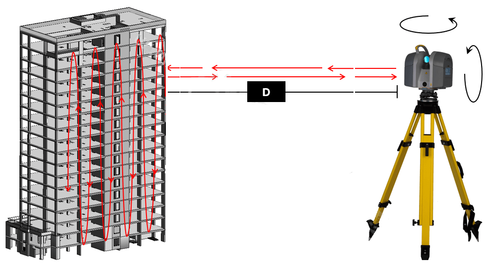
A terrestrial laser scanner sends laser pulses towards surrounding surfaces and calculates their position relative to the scanner. Each measurement becomes a point with an X, Y and Z coordinate. Large numbers of these measurements create a three-dimensional representation of the surveyed environment.
One scanner position cannot normally see an entire building because walls, furniture, columns and other objects create blind spots. The surveyor therefore moves the scanner through multiple overlapping positions and later combines those scans into one coordinated dataset.
What Is Terrestrial Laser Scanning?
Terrestrial laser scanning (TLS) is ground-based laser scanning carried out from static scanner positions inside or around a building, structure or site.
It is particularly suitable for building surveys because each scan captures a dense field of visible spatial measurements. Multiple scanner positions can then be registered together to represent rooms, floors, façades and other connected areas within a common three-dimensional coordinate system.
The term LiDAR refers more broadly to laser-based distance measurement technology. Terrestrial laser scanning is one surveying application of LiDAR; airborne, mobile and other LiDAR systems use related principles for different environments.
How Our Laser Scanning Survey Works
01
Send the Brief
Provide the site address, survey extent, existing plans if available, intended use of the data and required outputs.
02
Plan the Survey
We confirm access, coverage, required level of detail and any coordinate, datum or project control requirements.
03
Scan the Site
Our surveyor captures the accessible areas from multiple scanner positions with sufficient overlap between adjacent scans.
04
Register the Data
Individual scans are aligned into one coordinated Point Cloud using professional registration software.
05
Quality Review
The survey dataset is reviewed for registration, coverage and suitability for the agreed project outputs.
06
Deliver
We issue the registered Point Cloud or continue through to the agreed DWG, PDF, Revit or BIM deliverables.
Laser Scanning Accuracy: Scanner Specification vs Survey Accuracy
Accuracy is one of the main reasons project teams choose professional laser scanning, but it should not be reduced to one number printed on a scanner specification sheet.
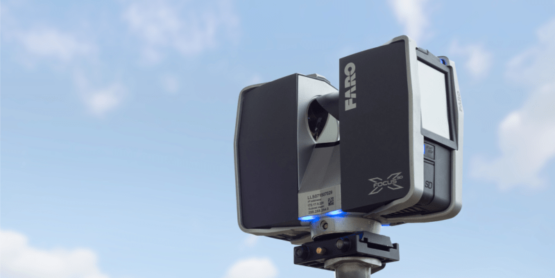
Measured Survey 365 uses professional FARO terrestrial laser scanners. Our current equipment includes FARO Focus systems capable of dense high-speed capture and millimetre-class instrument measurement under suitable conditions.
The quality of the complete laser scanning survey also depends on scanner range, survey geometry, number and placement of scanner positions, overlap between scans, registration quality, surface conditions, survey control and the tolerance required by your project.
For high-tolerance projects: tell us the required coordinate system, project grid, datum, control requirements and expected tolerance before the survey. Scanner specification and final registered survey accuracy are related, but they are not exactly the same thing.
Main Benefits of Professional Laser Scanning
Scanning records a large quantity of visible geometry rather than only a small collection of selected dimensions.
Large volumes of measured information can be captured efficiently during a coordinated site visit.
Irregular walls, roof forms, façades and connected spaces can be documented more effectively than through isolated manual measurements.
Visible surfaces can be recorded without physically touching sensitive architectural fabric.
The same registered scan can support additional measurements, CAD drawings or modelling within the originally captured survey scope.
Produced drawings and models can be reviewed against the underlying measured Point Cloud.
Laser Scanning Deliverables & Software Compatibility
A laser scan is only useful if your project team can use the resulting information. Tell us which software and downstream workflow you use before processing so that the required delivery format can be agreed correctly.
| Required Output | Typical Format | Typical Use |
|---|---|---|
| Registered Point Cloud | RCP / RCS or agreed format | ReCap, AutoCAD and Revit workflows. |
| 2D CAD Drawings | DWG | Architectural and engineering plans, elevations and sections. |
| Review Drawings | Review, issue, printing and project coordination. | |
| Revit / BIM | RVT | Scan-to-BIM and architectural modelling where included in the project scope. |
Our processing and drawing workflows use professional software including FARO Scene, Autodesk ReCap, AutoCAD and Revit.
If the registered 3D dataset itself is your main required deliverable, see our dedicated Point Cloud Survey service. For most clients searching generally for laser scanning, however, this page represents the complete site-capture service and the available downstream outputs.
Laser Scanning vs Manual Measurement vs Total Station
3D laser scanning is not the only surveying method, and different instruments are appropriate for different jobs. Its strongest advantage for complex existing-condition surveys is the quantity and completeness of visible geometry captured.
| Survey Method | How Data Is Captured | Best Suited To | Main Consideration |
|---|---|---|---|
| Tape / Disto | Selected individual dimensions | Simple rooms and limited checks | Complex geometry requires extensive manual recording and reconstruction. |
| Total Station | Selected precise surveyed points | Survey control, topographical surveys and targeted observations | The operator chooses which individual points need to be measured. |
| 3D Laser Scanner | Dense measurements of visible surfaces | Buildings, complex geometry, as-built records and digital reality capture | Requires line of sight, sufficient scan positions and professional registration. |
3D Building Laser Scanning
Building laser scanning is one of our core applications. It provides architects and designers with an accurate measured reference where existing architectural drawings are missing, simplified or no longer match the building.
Internal and external scanning can support:
- floor plans;
- external elevations;
- building sections;
- roof geometry;
- refurbishment and retrofit design;
- planning and architectural work;
- commercial fit-out;
- heritage documentation;
- Scan-to-BIM and Revit modelling.
If you principally require the final architectural plans, elevations and sections rather than raw scan data, see our Measured Building Survey service.
Laser Scanning for Construction & As-Built Surveys
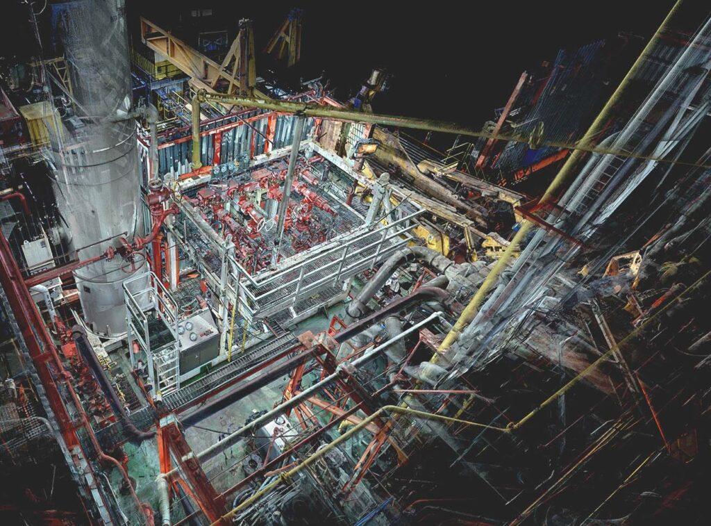
Laser scanning can create a measured record of completed visible works during or after construction. This gives contractors, designers and project teams a common digital reference for reviewing existing conditions.
Typical construction applications include:
- recording completed geometry;
- as-built documentation;
- checking existing conditions before fabrication;
- fit-out coordination;
- capturing conditions before subsequent construction stages;
- supporting comparison with supplied design information;
- providing measured data for future alterations.
If your required final result is specifically a set of post-construction plans, elevations or sections, see our As-Built Drawing Services.
Laser Scanning for Heritage & Listed Buildings
Historic buildings often contain geometry that is difficult to describe efficiently using isolated dimensions: uneven walls, decorative façades, vaulted spaces, irregular stairs, complex roof forms and architectural details accumulated over many years.
Terrestrial laser scanning is particularly useful in these environments because it records visible geometry without physically touching the architectural surfaces.
The required scanning density and downstream drawing detail should still be defined according to the project. A planning elevation does not necessarily require the same capture and production specification as a detailed conservation record.
What Laser Scanning Cannot Capture
A terrestrial laser scanner records surfaces that are visible from the scanner position. It does not see through walls and it cannot automatically record geometry that is completely hidden by physical obstructions.
A normal laser scanning survey therefore does not automatically reveal:
- pipes and cables concealed inside walls;
- buried underground utilities;
- structural elements hidden behind finishes;
- geometry inside inaccessible closed voids;
- surfaces permanently obscured from all scanner positions.
Glass, mirrors, highly reflective materials and some dark or absorptive surfaces may also require special consideration during capture or processing.
Scanner quality is only part of the job. A reliable survey also depends on professional scanner positioning, sufficient overlap, reduction of blind spots, registration and appropriate quality checks.
Laser Scanning Services in London
We provide professional laser scanning services in London for residential, commercial, construction and heritage projects throughout Greater London.
London projects frequently involve complicated access, occupied buildings, narrow plots, historic geometry, multiple floors and dense neighbouring development. A well-planned terrestrial laser survey can capture a large quantity of existing-condition information efficiently while minimising disruption to occupants and project teams.
Our London scanning projects range from residential properties and commercial buildings to complex historic sites. We also undertake suitable laser scanning projects throughout the wider UK.
Recent Laser Scanning Project Examples
Real project examples are often more useful than generic claims about survey technology. The following recent projects used 3D laser scanning as part of the measured survey workflow:
Historic Property — London W13
3D laser scanning and measured survey producing floor plans, elevations, sections, site information and Point Cloud data.
Historic Commercial Property — Hastings
Laser scanning of complex historic commercial geometry with delivery of plans, elevations, sections and Point Cloud data.
Mixed-Use Property — Esher KT10
3D laser scanning and topographical survey producing existing floor plans, elevations, site plan and Point Cloud.
VIEW MORE MEASURED SURVEY & LASER SCANNING PROJECTS →
How Much Does Laser Scanning Cost?
The cost of a laser scanning survey depends on the amount of site capture, registration and downstream production required. A simple price per square metre is not reliable because two buildings of the same area can require very different numbers of scanner positions and different deliverables.
Important cost factors include:
- building or site size;
- number of rooms and floors;
- layout complexity;
- number of scanner positions;
- visibility and occlusion;
- required scan density;
- survey control and coordinate requirements;
- access restrictions and working hours;
- Point Cloud processing;
- CAD, Revit or BIM deliverables.
For a detailed explanation of how survey pricing is calculated, see our Measured Survey Cost Guide.
Need the Actual Price for Your Project?
Send us the site address, available plans and required outputs. We can review the real survey scope and provide a project-specific quotation.
Which Survey Service Do You Actually Need?
Laser scanning is often the first technical step, but the final product depends on what your project team needs to receive.
| Your Requirement | Recommended Service |
|---|---|
| Come to site and digitally capture the existing building or structure | Laser Scanning Services — this page |
| Registered 3D Point Cloud as the main final dataset | Point Cloud Surveys |
| Existing floor plans, elevations and sections | Measured Building Survey |
| Post-construction record drawings | As-Built Drawings |
| You already have a Point Cloud and need DWG drawings | Point Cloud to 2D CAD |
Why Choose Measured Survey 365 for Laser Scanning?
Professional terrestrial laser scanning equipment for residential, commercial, construction and heritage projects.
One workflow can cover site capture, scan registration, Point Cloud processing and final architectural deliverables.
The same laser survey can support Point Cloud, DWG/PDF drawings and Revit/BIM requirements.
Projects undertaken across Greater London and suitable sites throughout the wider UK.
More than one thousand completed survey projects and thousands of issued architectural drawings.
We price the actual site, coverage and deliverables rather than forcing every project into the same generic package.
Laser Scanning FAQ
What is laser scanning in surveying?
Laser scanning is a surveying method that captures visible surfaces as large numbers of measured three-dimensional points. Multiple scanner positions are registered together to create a coordinated digital record of the building, structure or site.
Do you provide laser scanning services in London?
Yes. We provide professional 3D laser scanning services throughout Greater London for residential, commercial, construction and heritage projects, as well as suitable projects across the wider UK.
What is the difference between 3D laser scanning and a Point Cloud?
Laser scanning is the site capture process. A Point Cloud is the three-dimensional measured dataset created after the individual scans have been registered together.
How accurate is 3D laser scanning?
Professional terrestrial scanners provide millimetre-class measurement capability under suitable conditions. The quality of the complete registered survey also depends on scanner positions, overlap, registration, control, surface conditions and the tolerance required by the project.
Can laser scanning produce floor plans and elevations?
Yes. Registered laser scan data can be used as the measured source for floor plans, external elevations, building sections, roof plans and other agreed architectural drawings.
Can laser scanning be used for BIM and Revit?
Yes. The registered Point Cloud created from the laser scanning survey can provide the measured reference for Scan-to-BIM and Revit modelling. The required modelling content and detail should be agreed separately from the site scanning scope.
Does laser scanning see through walls?
No. Terrestrial laser scanning records visible surfaces and requires line of sight. It does not automatically reveal concealed services, buried utilities or structure hidden behind finishes.
How long does a laser scanning survey take?
Survey time depends on the size of the site, number of rooms and floors, complexity, required scan density and access. Smaller buildings may be captured within hours, while large or complicated sites can require longer.
What files can I receive after laser scanning?
Depending on the agreed scope, outputs can include registered Point Cloud data, DWG CAD drawings, PDF drawings and Revit/BIM models. Point Cloud delivery can be prepared for agreed Autodesk workflows such as ReCap, AutoCAD and Revit.
How much does laser scanning cost in London?
Laser scanning is priced according to the actual survey scope. Important factors include building size, number of rooms and floors, site complexity, access, number of scan positions, processing requirements and whether Point Cloud, CAD or BIM outputs are required.
What do you need to provide a laser scanning quote?
Send the complete property or site address, the areas that need to be scanned, existing plans if available, your required outputs and project deadline. If your team has a survey specification, coordinate system or tolerance requirement, send that as well.
Need Professional Laser Scanning?
Send us the site address, existing plans and required deliverables. We will review the actual survey scope and confirm the most appropriate scanning and delivery workflow.
