
When embarking on a new construction or landscaping project, looking beyond the walls of the building is essential. A professional topographical survey (or land survey) provides the detailed geographical data required to understand the exact characteristics of your site, from precise ground levels to the legal positioning of boundaries.
What is a Topographical Survey?
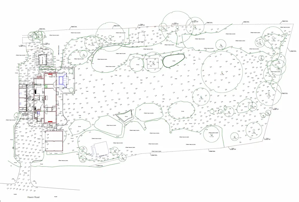
Unlike a standard measured building survey that focuses on the structure itself, a topographical survey maps the entire site. Using Total Stations and GPS equipment, surveyors identify both natural and man-made features. This includes spot heights, contours, drainage positions, utility covers, and significant trees.
Why London Projects Require Accurate Land Data
In the dense urban fabric of London, space is at a premium. Small errors in site data can lead to massive legal and structural headaches. An accurate survey is vital for:
- Boundary Dispute Prevention: Many London properties rely on historic records. A survey helps clarify positions in accordance with HM Land Registry boundary guidelines.
- Level Analysis: Essential for basement excavations and “Rights of Light” assessments under the Prescription Act 1832.
- Design Foundation: Architects need accurate site levels to design drainage systems and ensure the new structure integrates perfectly with the existing terrain.
Key Deliverables of a Topo Survey
A comprehensive topographical survey should be delivered in 2D AutoCAD (DWG) or 3D formats, providing:
- Site Levels & Contours: Critical for understanding the “fall” of the land and managing surface water run-off.
- Permanent Features: Mapping of existing walls, fences, paths, and neighboring building footprints.
- Utility Mapping: Identification of visible manhole covers and service points to avoid costly strikes during excavation.
- Tree Surveys: Detailed positions and canopy spreads, often required for Tree Preservation Orders (TPOs) by local London councils.
Integration with BIM and Revit
For modern developers, topographical data is no longer a flat file. By integrating land data into BIM and Scan-to-Revit workflows, we create a complete 3D environment. This allows for precise volume calculations (cut and fill) and ensures that the digital twin reflects the entire site, not just the building shell.
Professional Standards and Accuracy
At Measured Survey 365, all our land surveys are conducted to the highest industry benchmarks. We adhere strictly to the RICS Measured Surveys of Land, Buildings and Utilities specifications, ensuring that the data you receive is legally robust and technically flawless.
Secure Your Site Data Today
Avoid boundary disputes and design errors with a millimeter-accurate topographical survey. We cover all areas of London and the South East, providing rapid turnaround and fixed-price quotes. Book your site survey now and get a quote within 30 minutes.
