
Navigating the complexities of the UK planning system can be a daunting task for homeowners and developers alike. Whether you are extending a terraced house in Fulham or converting a commercial space in the City, a professional measured building survey is the first and most critical step in ensuring your planning application is validated and approved.
The Legal Framework: Why Accuracy is Non-Negotiable
In England, planning permission is governed primarily by the Town and Country Planning Act 1990. Local Planning Authorities (LPAs) across London, such as Westminster City Council or the Royal Borough of Kensington and Chelsea, have strict validation requirements. If your drawings are inaccurate—even by a few centimetres—you risk not only the refusal of your application but also potential enforcement action under the Planning Act 2008.
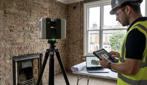
Submitting “approximate” measurements taken with a manual tape measure often leads to “Request for Further Information” (RFI) delays, which can set your project back by months. This is why 3D laser scanning has become the industry benchmark for planning in the capital.
Essential Drawings for a Successful Planning Application
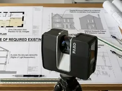
To meet the national and local validation list requirements, your application must typically include a suite of “Existing” drawings. These provide the baseline against which your “Proposed” designs are judged. According to Ministry of Housing, Communities & Local Government guidelines, you will need:
- Existing Floor Plans: These must show the internal layout, wall thicknesses, and structural openings. Precision is vital for calculating Gross Internal Area (GIA), which impacts CIL (Community Infrastructure Levy) charges.
- Existing Elevations: Detailed drawings of every facade. In London’s Conservation Areas, councils require exact mapping of architectural features, brickwork patterns, and window styles to ensure “character preservation.”
- Existing Sections: Vertical slices through the building showing floor-to-ceiling heights and roof pitches. This is crucial for “Rights of Light” assessments in dense urban rows.
- Roof Plans: Often overlooked, but essential for attic conversions (Dormer extensions) to show chimneys, parapet walls, and neighboring structures.
BIM & Revit in the Planning Phase
While 2D PDF drawings are the standard submission format, many advanced projects in London now utilize BIM and Scan-to-Revit models during the design phase. This allows architects to perform solar studies and 3D shadow analysis, which can be the deciding factor for planning officers in sensitive urban locations.
The Role of Topographical Surveys in Planning
For new builds or significant rear extensions, a topographical (land) survey is often mandatory. Under the National Planning Policy Framework (NPPF), applications must demonstrate an understanding of the site’s topography, drainage, and boundary treatments. An accurate topo survey prevents “boundary disputes”—a common and expensive legal headache in London’s residential sectors.
Permitted Development Rights (PDR) vs. Full Planning
Some minor works fall under Permitted Development Rights. However, even for a Lawful Development Certificate (LDC), you must provide evidence that your project fits within specific volume and height limits. An accurate survey provides the mathematical proof needed to satisfy the planning officer that you haven’t exceeded these strict thresholds.
Why London Properties Require Special Expertise
London’s housing stock is uniquely challenging. Georgian and Victorian properties are notorious for “structural movement”—meaning walls are rarely vertical and floors are seldom level. Traditional surveying methods fail to capture these “bows” and “leans.” 3D laser scanning captures 1 million points per second, ensuring your architect has a “digital twin” that accounts for every structural anomaly, reducing risk during the construction phase.
Conclusion: Investing in Accuracy
A measured survey is not just a drawing; it is an insurance policy for your project. By adhering to RICS professional standards, you ensure that every stakeholder—from the planning officer to the party wall surveyor—is working from a single version of the truth.
Get Your Planning Survey Today
At Measured Survey 365, we provide RICS-compliant measured building surveys across all London Boroughs. Whether you need 2D CAD drawings or a full 3D Point Cloud, we deliver precision within 3-5 working days. Get a fixed-price quote online or call our London team for a consultation.
