
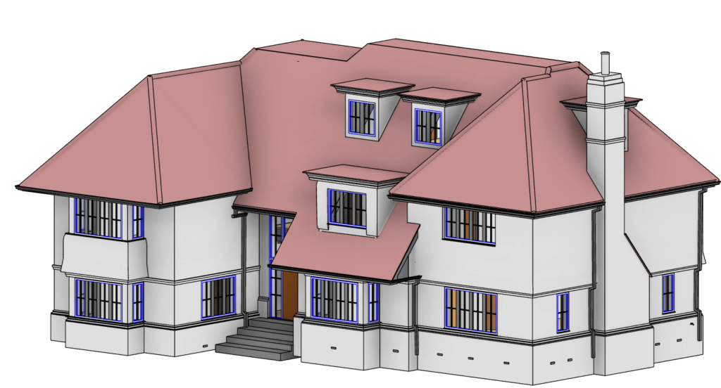
Turn Laser Scan Data into an Accurate Existing-Condition Revit Model
Professional Scan to BIM services for architects, developers, contractors and design teams across London and the UK. We convert registered laser-scan Point Clouds into structured Revit models developed around the geometry, information and modelling scope your project actually requires.
Point Cloud → Revit • Existing-Condition BIM • Project-Specific Model Scope • London & UK
Already have a Point Cloud? Send the data and BIM brief. If not, we can provide the laser scanning first.
Measured Source
Registered Point Cloud
Primary Output
Revit / BIM Model
Coverage
London & UK
Scan to BIM Services at a Glance
- Point Cloud to Revit modelling
- Existing-condition BIM models
- Laser scan to BIM workflows
- Revit models for refurbishment and retrofit
- Architectural existing-condition models
- Models aligned to supplied project coordinates where required
- Project-specific model scope and information requirements
- Work from your existing registered Point Cloud
- Optional 3D laser scanning where survey data does not yet exist
Professional Scan to BIM Services for Existing Buildings
Scan to BIM is the process of using measured laser-scan or Point Cloud data as the spatial reference for creating a structured digital model of an existing building.
Instead of modelling from outdated plans, approximate dimensions or assumptions, the Revit model is developed against measured existing-condition data captured from the physical building. This gives architects, engineers, contractors and developers a stronger digital base for refurbishment, retrofit, redevelopment and design coordination.
The Point Cloud itself is not a BIM model. It is a dense collection of measured spatial points representing visible surfaces. During the Point Cloud to Revit process, those measured surfaces are interpreted into structured model elements such as walls, floors, roofs, openings, columns, stairs and other components included in the agreed project scope.
A useful BIM model is not simply the most detailed model possible. Before production begins, the project should define which elements need to be modelled, the intended use of the model, the required geometric detail and any project-specific information requirements.
From Point Cloud to Revit BIM Model
The main strength of a Scan to BIM workflow is that the 3D model is developed from a dense measured reference rather than reconstructed only from conventional plans.
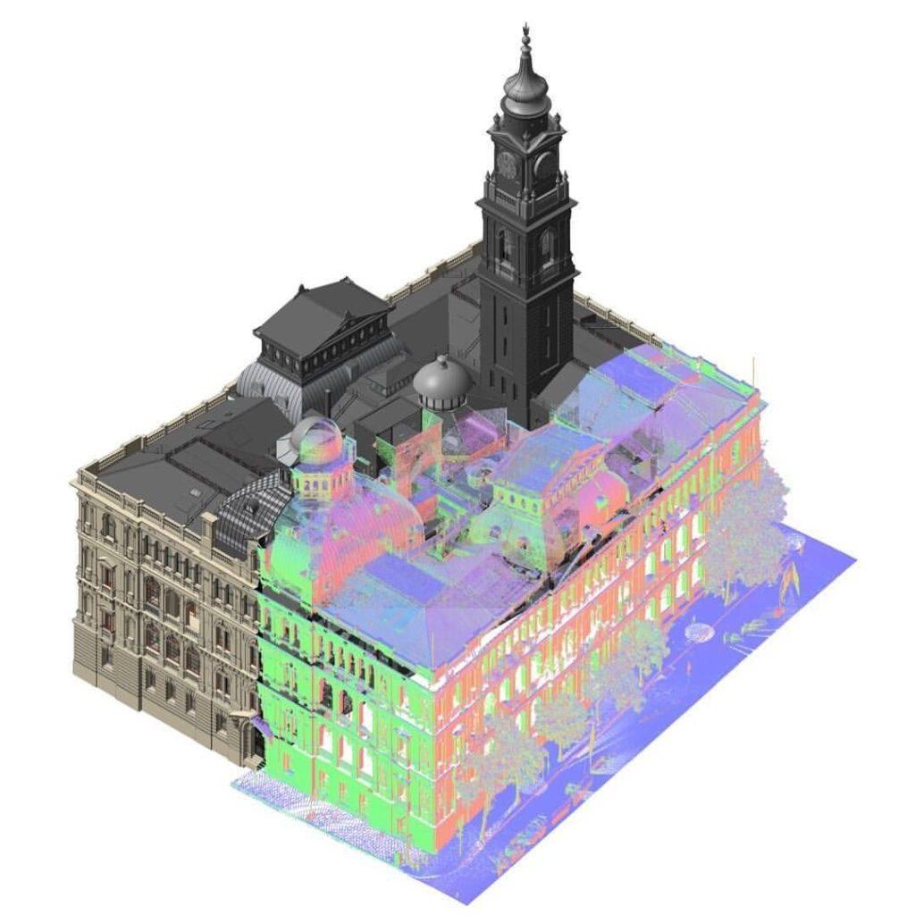
A registered Point Cloud can represent millions of measured locations across the visible surfaces of a building. The modeller references that data in Revit and creates the required structured building elements according to the agreed BIM brief.
The original Point Cloud can remain available throughout production as the measured reference for checking model geometry and resolving irregular existing conditions.
Typical Scan to BIM Workflow
Laser Scan → Registered Point Cloud → Revit Modelling → Model Review → BIM Deliverable
What Do You Receive from a Scan to BIM Project?
The exact BIM deliverable should be matched to the intended project use. A feasibility or early-design model may require relatively simple existing geometry, while a detailed refurbishment project may require significantly more architectural information.
Native Revit Model
An existing-condition RVT model developed from the registered Point Cloud and issued in the agreed Revit version.
Architectural Elements
Walls, floors, roofs, openings, stairs, columns and other visible building elements included within the agreed modelling scope.
Project Coordinates
The Revit model can follow the supplied Point Cloud origin, project grid, datum and coordinate requirements where defined.
Client Revit Standards
Where supplied, Revit templates, naming conventions and modelling requirements can be reviewed and incorporated into the scope.
Point Cloud Reference
The original survey dataset can remain available as the measured reference against which model geometry is reviewed.
Additional Outputs
2D model views, DWG/PDF extracts or other agreed digital deliverables can be included where required.
Point Cloud vs Revit Model: What Is the Difference?
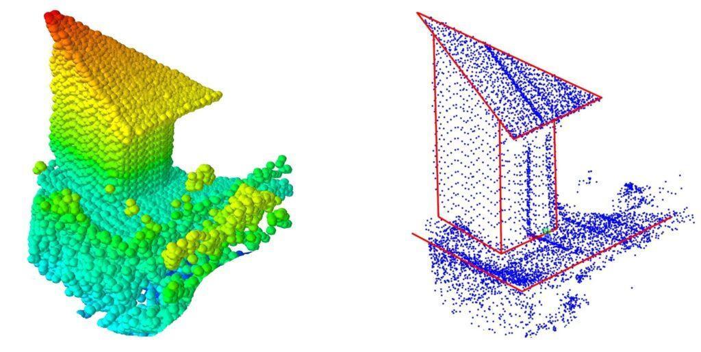
| Point Cloud | Revit / BIM Model |
|---|---|
| Measured XYZ data representing visible building surfaces. | Interpreted building elements developed using the Point Cloud as the spatial reference. |
| Excellent for direct measurement and checking real existing geometry. | Designed for modelling, design development, coordination and BIM workflows. |
| Contains measured points rather than intelligent building objects. | Contains organised model elements defined according to the agreed project scope. |
| Can preserve irregular real-world geometry directly. | Requires decisions about how irregular real conditions are represented as model elements. |
If the registered 3D survey dataset itself is your main required output, see our Point Cloud Survey service.
Level of Detail vs Level of Information Need
Scan to BIM enquiries often use terms such as LOD 200, LOD 300 or LOD 350. These can be useful shorthand, but a number alone does not fully define what a project team expects to receive.
For a reliable BIM brief, the more important question is: what information and geometry does the project actually need for its intended purpose?
A clear Scan to BIM brief should define:
- which building elements are included or excluded;
- the intended use of the model;
- required geometric detail;
- required non-geometric information where applicable;
- Revit version and client template;
- project coordinates and datum;
- naming or classification requirements;
- required outputs and exchange formats.
Specifying unnecessary detail can increase modelling time and cost without improving the usefulness of the model. Where a BIM information requirement, modelling specification or Revit template already exists, send it with the enquiry so the quotation can be based on the real scope.
When Is Scan to BIM the Right Choice?
Create a measured existing-condition Revit model before internal layouts, façades or other building elements are redesigned.
Use measured existing geometry as the digital base for upgrading, repurposing or extending an existing property.
Model offices, retail, hospitality and mixed-use properties where several disciplines need a shared existing-condition reference.
Use dense measured data where irregular walls, roofs and historic geometry make old drawings unreliable.
Give architects, engineers and consultants a coordinated measured model against which proposed work can be developed.
Create a structured digital building record where conventional 2D drawings alone are not sufficient for the intended workflow.
Scan to BIM for Refurbishment & Retrofit
Existing buildings are one of the strongest applications for laser scan to BIM. Original drawings may be incomplete, simplified or no longer represent alterations made over the lifetime of the property.
Using the measured Point Cloud as the source allows the existing-condition model to reflect the building captured during the survey rather than relying only on historic documentation.
This can be particularly useful for refurbishment and retrofit projects where proposed design work must coordinate with existing walls, floors, structural geometry, roof forms and other visible building constraints.
Scan to BIM for Commercial Buildings
Commercial refurbishment frequently involves multiple design disciplines working on the same existing building. Offices, retail units, hospitality properties, warehouses and mixed-use buildings can therefore benefit from a common measured Revit base model.
The required BIM scope should still be tailored to the project. An architectural fit-out model, for example, may need a different set of elements and detail from a multidisciplinary redevelopment model.
Scan to BIM for Heritage & Irregular Buildings
Historic buildings often contain geometry that is difficult to reconstruct reliably from conventional drawings alone: walls may not be straight, floors may vary in level and roofs, stairs or façades may contain highly irregular forms.
Laser scanning records those visible conditions as dense spatial data. The Revit modeller can then use the Point Cloud to understand the real geometry before deciding how it should be represented within the structured BIM environment.
Important: a Revit model is still an interpretation of the measured building. Highly irregular historic geometry should therefore be modelled according to the level of representation actually required by the project rather than automatically simplified or over-modelled.
Our Scan to BIM Workflow
01
Project Brief
Send the site address or Point Cloud, intended model use, required Revit version and modelling requirements.
02
Data Review
We review Point Cloud coverage, registration, project complexity and whether the survey data is suitable for the requested model.
03
Agree Model Scope
Included elements, information requirements, geometric detail, coordinates and delivery standards are confirmed.
04
Revit Modelling
The existing-condition model is developed using the registered Point Cloud as the measured spatial reference.
05
Quality Review
Modelled geometry is reviewed against the source data and checked against the agreed BIM scope.
06
Digital Delivery
The final Revit/BIM files and any additional agreed outputs are issued to the project team.
Scan to BIM Quality Control
A BIM model is an interpretation of measured survey data rather than a replacement for the original Point Cloud.
Real existing buildings contain construction tolerances, leaning or uneven surfaces, historic alterations and geometry that does not always fit idealised digital objects. During modelling, these real conditions need to be represented according to the agreed project purpose.
Our workflow uses the registered Point Cloud as the measured reference and checks the developed model against that source data within the agreed modelling scope.
Can Scan to BIM Include MEP or Structural Elements?
MEP, structural or other specialist elements can only be modelled reliably where suitable source information exists and those elements are included within the agreed scope.
A terrestrial laser scanner captures visible geometry. It does not see concealed services inside walls, hidden structural connections or components obscured above closed ceilings.
Where specialist systems need to be represented, the model may need to combine Point Cloud geometry with existing drawings, consultant information or other survey data supplied by the project team.
Do not assume that a laser scan automatically creates a complete MEP or structural BIM model. The model can only represent elements supported by visible survey data or other reliable project information.
Already Have a Point Cloud?
If you already have suitable registered Point Cloud data, there is no need for us to automatically repeat the site survey.
Send the Point Cloud or a representative sample together with your BIM brief. We can review:
- Point Cloud format;
- registration and coverage;
- building complexity;
- required Revit model scope;
- project coordinates and datum;
- required model detail;
- Revit version;
- delivery programme.
Common workflows include Autodesk RCP/RCS and exchange formats such as E57. Other Point Cloud formats can be reviewed before quotation.
Don’t Have a Point Cloud Yet?
If the property has not yet been scanned, our survey team can provide the complete workflow from physical building capture through to the final BIM model.
Use our 3D Laser Scanning Services where the main requirement is site capture and Point Cloud creation.
If you also need conventional floor plans, elevations or sections alongside the model, see our Measured Building Survey service.
Scan to BIM vs Scan to CAD
| Scan to CAD | Scan to BIM |
|---|---|
| Produces conventional 2D drawings. | Produces a structured three-dimensional building model. |
| Typical outputs: DWG and PDF plans, elevations and sections. | Typical output: native Revit model and agreed BIM deliverables. |
| Best where the design workflow is principally drawing-based. | Best where a coordinated 3D existing-condition model is required. |
If you only require conventional drawings from existing scan data, use our Scan to CAD service.
How Much Does Scan to BIM Cost?
Scan to BIM cost depends primarily on the amount of modelling required rather than only the floor area of the building.
Important pricing factors include:
- building size;
- building and architectural complexity;
- quality and completeness of the supplied Point Cloud;
- elements included within the BIM scope;
- required geometric detail;
- required information and parameters;
- client Revit standards and templates;
- coordinate requirements;
- additional CAD or PDF outputs;
- required turnaround.
For the most accurate quotation, send the Point Cloud or property details together with the required Revit scope. We can then price the real modelling workload rather than relying on a generic rate.
Need an Existing-Condition Revit Model?
Send us your Point Cloud or property details, required BIM scope and project deadline. We will review the data and provide a project-specific quotation.
Why Choose Measured Survey 365 for Scan to BIM?
If required, the same team can coordinate laser scanning, Point Cloud processing and downstream Revit modelling.
Already have a registered Point Cloud? We can review it and model directly from suitable supplied data.
Model only the elements and level of information your project actually requires.
Our workflows are focused on measured existing-condition data for architectural and construction projects.
The same measured dataset can support Revit modelling and conventional DWG/PDF deliverables when required.
Scan to BIM production for residential, commercial, heritage and complex existing buildings.
Scan to BIM FAQ
What is Scan to BIM?
Scan to BIM is the process of using measured laser-scan or Point Cloud data to create a structured digital model of an existing building, commonly in Autodesk Revit.
What is Point Cloud to Revit?
Point Cloud to Revit uses a registered Point Cloud as the measured spatial reference for creating an existing-condition Revit model.
Can you work from a Point Cloud supplied by another survey company?
Yes. We can work from suitable registered Point Cloud data produced by another survey provider or your own team. Send a representative sample so the coverage and compatibility can be reviewed before quotation.
What level of detail should I request?
The correct amount of model detail depends on the intended project use. The BIM brief should define the required elements, geometry and information rather than automatically requesting the maximum possible detail.
Can you use our Revit template?
Where a Revit template, modelling standard or naming convention is supplied, we can review it and include the agreed requirements within the project scope.
Does Scan to BIM include the laser scanning survey?
It can. If a suitable registered Point Cloud already exists, we can work directly from it. If the property has not been surveyed, our team can provide the 3D laser scanning and Point Cloud registration first.
Can Scan to BIM include MEP?
MEP elements can only be modelled where appropriate source information exists and they are included within the agreed project scope. Laser scanning records visible geometry and cannot automatically reveal concealed services inside walls or closed ceilings.
Can hidden structural elements be modelled?
Not reliably from visible Point Cloud data alone. Hidden elements should only be included where suitable drawings, investigation data or other reliable source information are available.
What is the difference between Scan to BIM and Scan to CAD?
Scan to BIM creates a structured 3D building model, typically in Revit. Scan to CAD converts Point Cloud data into conventional 2D drawings such as floor plans, elevations and sections.
What Point Cloud formats can be used?
Common workflows include Autodesk RCP/RCS and exchange formats such as E57. Other registered Point Cloud formats can be reviewed before the modelling scope is confirmed.
How much does Scan to BIM cost?
Pricing depends on building complexity, Point Cloud quality, modelled elements, required geometric and information detail, Revit standards, coordinates and delivery programme. Send the data and BIM brief for a project-specific quotation.
Ready to Convert Your Point Cloud into Revit?
Send us the registered Point Cloud or property details, model requirements and project deadline. We will review the scope and provide a fixed project quotation.
